Over the past two decades, USAID has made significant investments in the water and energy sectors of Armenia. Some of these programs created very useful reports about water and energy resources in Armenia, including the Water Resources Atlas of Armenia (2008), the Assessment of Groundwater Resources of the Ararat Valley, and the National Program on Energy Saving and Renewable Energy of Republic of Armenia (2007). These reports contain useful maps and geographic data. However, they are usually part of a much larger report that is not widely accessible to the public. On top of USAID's work in energy and water, many other organizations, such as the World Bank, are also contributing valuable data for these sectors. And yet, this wealth of information on Armenia's water and energy sectors is siloed in individual reports.
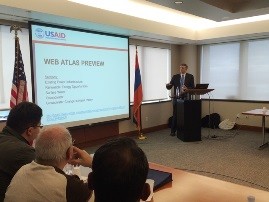
To address this issue, USAID came up with the idea of developing a Water and Energy Web Atlas to compile and consolidate geographic information from a variety of sources. The goal was to provide a geospatial representation of Armenia’s energy and water resources to a wider audience. The web atlas was developed by the USAID Global Development Lab's GeoCenter, using Esri’s ArcGIS Online, Server, and Story Map technology. Brian Bakker, GeoCenter’s GIS specialist who developed the application, rolled out the atlas to Armenian stakeholders on November 12, 2015. Representatives from the Ministry of Nature Protection, Ministry of Agriculture, Ministry of Energy, donor groups, academia, and other groups were present.
Who will use it?
The Water and Energy Web Atlas was initially designed to serve as a tool for stakeholders involved in USAID Armenia’s new “Advanced Science and Partnerships for Integrated Resource Development” (ASPIRED) program. As the database grew, it became apparent that this resource could have a bigger influence. Today, the web atlas is designed to help a variety of internal and external audiences better understand the challenges and opportunities Armenia is facing with regard to energy and water. Potential users include USAID and other donor programs, government ministries, NGOs, academic institutions, and the public at large. The Armenia Water and Energy Web Atlas is publicly accessible and can be found at http://tinyurl.com/amwebatlasen
What is the future for the application?
Currently, USAID’s GeoCenter is maintaining the website. However, USAID ultimately wants to see the web atlas live long after the ASPIRED program or GeoCenter's engagement. USAID will be working to find a suitable in-country partner to take ownership of and build upon the initial product developed by the GeoCenter.
What is unique about this tool?
Historically, maps were created for a special purpose and printed on paper. Once published, the map was a static document that did not change. In recent decades, Geographic Information Systems (GIS) have emerged as a technology that has revolutionized the way we think about maps. No longer is a map a static document. With GIS, a user can interact with the map – zoom in and out, query the map, and filter the information through a myriad of criteria. In the early years of GIS, you had to be an expert and have GIS software installed on your computer. More recently, web-based GIS platforms have allowed ANYONE with a web browser to access GIS maps. Furthermore, in the past year or two geographers and statisticians have begun to think of maps as an avenue to tell a story. Maps are now being used by GIS professionals to clearly and concisely explain issues and phenomena to their users through web-based, interactive platforms. The Armenia Water and Energy Web Atlas is an example of this new type of map. It is truly unique for the country and the USAID mission as it provides a new way for communication and sharing information with stakeholders and citizens of Armenia.



Comment
Make a general inquiry or suggest an improvement.